By Lori Westerman, Class of 2006
“Mayor Daley foresaw the future for the public/private partnerships and made sure that neither politics not personalities would get in the way of getting done what needed to be done for the city”
Miles Berger, former director of the Department of Planning under Mayor Richard J Daley, 1992
The Podium – the development’s unique infrastructure

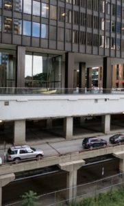
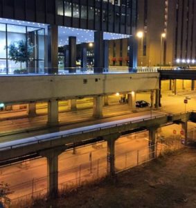
The Illinois Center is built on a multilevel, multiuse base made of reinforced concrete that allows a seamless transition from one building in the development to another. The use of an elevated development over the Illinois Center railyards was first mentioned in the 1958 Development Plan for the Central Area. Designers Fujikawa and Buenz said the centuries-old infrastructure concept was a natural for the development. Wacker Drive and North Michigan Avenue already are multilevel avenues and the Michigan Avenue Bridge (now the DuSable Bridge) over the River was designed to have upper and lower levels. “When we got into the job, the stage was set for an infrastructure. It’s kind of a planner’s dream to separate traffic this way and to turn our backs on it would have been wrong.” With the multilevel platform for the Illinois Center, “we can plug in any kind of a tower to the base, whether it’s an office building, an apartment building or whatever”. Said architect John Buenz, “the infrastructure’s what it’s all about. It involves a vertical organization of space rather than horizontal. From a humanist point of view, most cities have been built backwards. When we finish a building the people-support systems will already be there. It will be possible to walk from one end to another underground and through a most exciting environment. Maybe downtown will be dead at night but here we’ll have all the amenities for people to live, work and play.” 1

The podium was likely the first use of this concept in the United States and was designed to have 3-4 levels – one for local traffic at street level for cabs and vehicles used by building tenants; a second level for through traffic; and a third level for trucks, service vehicles and parking. A Pedway concourse level was designed between the first and second level although individual buildings may have been designed with additional levels. “But you won’t find a drawing of the superstructure. Ask the developers and they won’t be able to show you an overall view either. They aren’t being coy. It’s part of the plan to maintain complete flexibility throughout the 15-year period of building construction. Because it’s never been done before, the architects will have lots of basic problems to solve”. 2
In a conversation I had with Dirk Lohan, an architect familiar with the Illinois Center, he said that in addition to the flexibility and convenience the podium offered, another reason for its use was a concern about flooding since the land was almost level with the height of the River.
The podium for each building was poured in conjunction with a building’s construction and is owned by the building above it.
It’s all in the technicalities
Some sources say that One Illinois Center, 111 E Wacker Drive, is “technically not built on the air rights” because there had been a warehouse on that site and the railroad tracks had been removed on that building’s portion of the railyards so construction was allowed to begin in 1968 before the Planned Development was approved in 1969. I suspect Mayor Daley wanted to be certain nothing stood in the way of the developers proceeding with the project.
What’s in the neighborhood – but not in Illinois Center
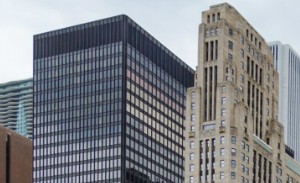
The Prudential Building and the (now) Aon Center were never included in the Illinois Center development since the Prudential’s $2.3M purchase of the air rights for that building and the land sold to the Standard Oil Company for their building in January,1968 were completed in separate Illinois Central transactions. The Blue Cross Blue Shield Building’s property was purchased from the Illinois Center developers in the 1990’s and is also not part of the Illinois Center. Millennium Park Plaza and 400 East Randolph are also built on the Illinois Central air rights land purchased in another transaction. Today the Illinois Center’s southern boundary is effectively Lake Street except for the residential buildings at the eastern end of Randolph.
Not all of the property along the western edge of the railyards and east of Michigan Avenue was part of the 83-acre air rights development and these buildings are still there today including the Old Republic Building (307 N Michigan Avenue, Vitzhum & Burns, 1925); 333 N Michigan Avenue (Holabird & Root, 1928); and the Shriners Building (no original completion date, remodel Holabird & Root, 1929-30). There were other buildings in this same strip of land on the railyards south of Water Street that were demolished to make way for construction.
Lakeshore East emerges
In 2002, the Illinois Center’s Planned Development was amended and the remaining 28 acres were purchased by Magellan Development and developed as Lakeshore East. The vision for a residential “city within the city” with a park and a school is now a reality.
To follow the current evolution and changes to this air rights development, search “PD 70 Chicago”.
The Illinois Center Pedway
 What would you need if you were one of the 50,000 pedestrians who walk through the complex each week? Among the shops are restaurants, hairdressers, barber shops, nail salons, a drug store, banks, coffee shops and even a dental clinic. “You can find anything here but an undertaker” said Mel Cross, president of the Illinois Center Merchants Association. 3
Most of these businesses and services aren’t visible from the street because the City wanted them to primarily meet the needs of people who lived and worked in the complex so it wouldn’t compete with State Street that had its own challenges at the time.
In keeping with the mid-century aesthetic, no business logos are visible as you look down the corridors. Instead they’re all the same – sleek and modern and of the same aluminum material.
Questions and Answers
When was the Wacker Drive extension from Michigan Avenue east to the Outer Lake Shore Drive Bridge completed?
The initial 300 feet (almost to Stetson) was completed in 1972 and paid for by one of the Illinois Center developers,Metropolitan Structures, as part of the 111 E Wacker Dr.construction. An additional 1500 feet, also partially paid for by IC Industrues, was added in 1975 extending Wacker to approximately Field Drive that was the edge of the “S Curve” at the time. Even though the entire 3-layer street was complete, only Upper Wacker Dr. was open to traffic until final connection to Lake Shore Drive happened after the “S Curve” was eliminated in the 1980’s.
When was the “S” curve construction on Lake Shore Drive completed that made the curve “gentler” and relocated Lake Shore Drive to the east?
The current S-curve includes much gentler bends starting around Randolph Street and ending just before Monroe Street. Construction on the project began in 1982 and concluded in late 1986. 4
What exactly are “air rights”?
The term comes from English Common law that says that if you own the ground, you own everything above it to Heaven.
Where does the Illinois Center Pedway section fit in the overall history of pedways in Chicago?
The original 1943-1951 pedway section on the lower level of today’s Block 37 was just a connection between the State and Dearborn Street subways providing a weather-protected convenience for CTA riders. When the Daley Center and the County Building were completed in 1965, pedways were still primarily for the convenience of tenants, but some retail was added as a building amenity.
Planning for the North Loop Redevelopment Project and the Illinois Center in the 1970’s included pedway connections as an essential element needed to bring people downtown to live and work and so developers were given incentives to include them. In the 1973 Chicago 21 Plan, there is a reference to the importance of “Pedestrian Walkway Systems – an underground, grade-level and above-grade system, lined with shops in galleria fashion”.
In 1982, a pedestrian study done by the Department of Transportation suggested creating weather-protected walkways linking major pedestrian traffic generators with public transportation, separation of pedestrians and vehicles and the need to protect pedestrians from air and noise pollution.
In the 1980’s and ‘90’s buildings were still being planned with pedway connections (for example, Thompson Center, BCBS, 120 N LaSalle) and when the 1988 sections opened along the lower level of Marshall Field’s, the economic advantages of retail offered to people outside those working in a specific building complex were clear.
Inclusion of pedways in new downtown developments was important when Richard J Daley was mayor but Richard M Daley is not a fan. I suspect the very powerful downtown merchants association was putting pressure on him but he said it was “because of security problems. When everybody’s below ground, the city becomes lonely and frightening” above ground. Some urban planners and architects feel pedways take away from the vitality of the city streets.
Was the idea of building on a podium well accepted at the time?
The AIA weighed in on the design in the report of a study completed in 1970 by noting that “here is a development which will involve investment of well over a billion dollars in private and public improvements which has not been planned and yet, the major features of its infrastructure have been crystallized without consideration of other modern options. Clearly the priorities of concern are out of order”. 5
Who owns the Illinois Center now?
111 E Wacker Dr. and 233 N Michigan Ave are owned by New York-based AmTrust. They purchased the buildings in 2015 for at least $375M. (Source: Crains, 6/24/2015). The Michigan Plaza Buildings (205/225 N. Michigan Avenue) are owned by Aegis Asset Management.
What are some “fun facts” about the Illinois Center?
The City required the development to have both east-west and north-south connections through the entire complex. Because that made the walkways very long, the developers considered “mechanical assistance” – a.k.a.moving walkways.
Routing of pedestrians along the riverbank through the 6-acre park and connecting Michigan Avenue with the lakefront without vehicular interruption were important goals. According to a 1968 planning document, this could be accomplished with an esplanade along the River’s edge that would offer recreational activities. “Walking, fishing, cycling and sitting and looking. This latter activity is very important and should receive special attention.”
The small domed building (now empty) on the northeast corner of Michigan and Randolph was built in the early 1970’s as the sales center for Harbor Point.
A new city junior college was proposed for east of the Prudential in 1967.
When the contractors were excavating for the installation of the 111 E Wacker building, they found cattle skulls and preserved pre-historic rocks.
Sources:
- “Major underground network planned for Illinois Center”, Chicago Tribune, 4/28/1974
- “Illinois Center Plans for the Future, Chicago Tribune, 12/5/1971
- “Illinois Center growing into futuristic city within a city” Chicago Tribune, 11/11/1984
- dnainfo, March 2016)
- “Report of a Study by the AIA Committee on Design”, May 1970.

